|
|
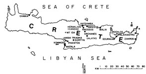
Map of Crete
Prehistoric Minoan sites are found throughout Crete, but are concentrated in the central and eastern parts of the island. The larger palatial establishments are at Knossos, Malia, and Phaistos, but others such as that at Kommos are known as well.
|
|
|
Map of Mesara area
See Introduction |
|
|
Kommos Site Plan, All Periods
A large portion of the Kommos site, established on a low hill along the shore of the Libyan Sea, is contained within the fenced area bought by the excavation for the Greek State. The Minoan town spread out on the hilltop to the north and on the hillside south of it. South of there was the Minoan civic center and, much later, the Greek Sanctuary was built above its ruins. Most of the Greek remains have been exposed, but earlier the Minoan town extended out beyond the fenced periphery of the site, especially to the north and east.
|
|
|
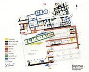
South Area Phase Plan
Sites originally chosen for settlement because of their proximity to fresh water, or to the sea, or exposure to a warming sun, or shelter from prevailing winds, as at Kommos, may be used for hundreds or even thousands of years. With one building succeeding another and habitation levels rising as erosion brought sediment down from upper hill slopes, the Kommos site became “layered” with successive superposed use levels, one above or even within another. On a single plan selected levels can best be shown graphically by using different colors, as in the illustration. At Kommos the first major period, Minoan, begins with the First or Protopalatial Period (yellow). It was followed by the Second or Neopalatial Period (black), that of Building T with its large central court. Not long after, during the Postpalatial Period, came Building P with its shipsheds (red) which were abandoned, along with the town, around 1200 BC. Then the Greek period began with the founding of its first, then second, then third temples (blue), which together lasted over a thousand years. The Minoan settlement served as town and port, with large civic buildings, and people lived in the town throughout the year. The Greek Sanctuary was probably used only seasonally; there was no surrounding town. |
|
|
South Coast with Site of Kommos
The western shore of the Mesara Plain. In the right foreground are beach umbrellas on the shore. The Kommos site (upper center, right) is obscured by trees. The background is framed by the Idaian Mountains, with Psiloritis, where Zeus is said to have been nurtured, on the upper right.
|
|
|
View of Site From South
The Kommos excavation site from the south, with the Libyan Sea on the left. The area of the Greek Sanctuary (center, left) is prominent, with houses of the Minoan town visible on the upper center. The tamarisk trees flourish near the sea since they can absorb moisture from onshore breezes.
|
|
|
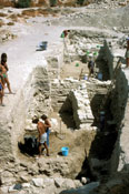
Excavation in the Southeast Area
Separate groups of workmen and supervisors excavating in the Southern Area in the early ‘90s. Looking north. In the foreground we see the newly discovered collapsed top of the Minoan pottery kiln built within the South Stoa of Building T (not yet discovered at the time). During the next excavation season the kiln and the area beyond it were cleared down to the level of the Central Court (see illustration in “Minoan Palaces and Shipsheds,” below).
|
|
|
Excavation in the Minoan Palace at Kommos
A deep exploratory trench exposes walls of storerooms of Minoan palatial structure T. Workmen collect potsherds in colored plastic buckets, while others (upper left) stand on upper, Greek levels to receive stones and baskets of earth being removed from the lower rooms.
|
|
|
Stone Anchors Found at Kommos
Excavation below the floor in a long gallery of Minoan Building P (see “Minoan Palaces and Shipsheds, below) exposes a broken Minoan limestone anchor (lower right) of the kind used by large seagoing ships. The anchor slab is pierced by three holes, the first large one (left) for the thick rope linking it to the ship, the two smaller ones for pointed wooden stakes intended to hold the anchor to the sea floor. Analyses shows that this anchor, as well as another partially exposed one (upper left), was quarried in Syria. In their present position they were reused as bases for wooden supports, perhaps for scaffolding when the gallery was being constructed.
|


